


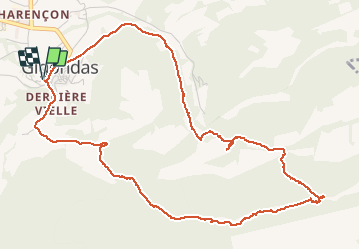
Tour des Dentelles de Montmirail

GOHIER
User

Length
6.3 km

Max alt
584 m

Uphill gradient
349 m
Km-Effort
11 km

Min alt
238 m

Downhill gradient
347 m
Boucle
Yes
Creation date :
2019-12-08 10:05:52.0
Updated on :
2019-12-15 09:01:47.693
3h01
Difficulty : Unknown

FREE GPS app for hiking
 SityTrail
IGN / Geographical institutes
SityTrail Plus
The world is yours!
About
Trail Walking of 6.3 km to be discovered at Provence-Alpes-Côte d'Azur, Vaucluse, Gigondas. This trail is proposed by GOHIER.
Description
Très joli tour au pied des falaises au-dessus des vignes
Positioning
Country:
France
Region :
Provence-Alpes-Côte d'Azur
Department/Province :
Vaucluse
Municipality :
Gigondas
Location:
Unknown
Start:(Dec)
Start:(UTM)
660210 ; 4891963 (31T) N.
Comments