Trail Walking Divatte-sur-Loire - Circuit de la haute chapelle  - Photo
© OpenStreetMap contributors
Length
Length
11.8 km
Max alt
Max alt
75 m
Uphill gradient
Uphill gradient
145 m
Km-Effort
Km-Effort  
13.7 km
Min alt
Min alt
22 m
Downhill gradient
Downhill gradient
143 m
Boucle
Boucle
Yes
Creation date :
2019-12-15 09:29:36.0
Updated on :
2019-12-15 13:39:25.655

(0 Reviews)

Walking
Walking
3h07
Difficulty : Unknown

Scan this QR Code to open this trail in the SityTrail application

FREE GPS app for hiking

Logo SityTrail SityTrail

IGN / Geographical institutes

Download SityTrail from the App Store Download SityTrail from Google Play

Logo SityTrail SityTrail World

The world is yours!

Download SityTrail from the App Store Download SityTrail from Google Play Download SityTrail on Huawei AppGallery

About

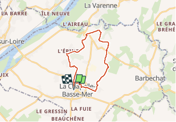
Trail Walking of 11.8 km to be discovered at Pays de la Loire, Loire-Atlantique, Divatte-sur-Loire. This trail is proposed by PhilippeLegault.

Description

Beaucoup de chemins goudronnés, à faire plutôt l’hiver par temps sec , pas d’abris en chemin.

Elevation profile

Positioning

Country:
France
Region :
Pays de la Loire
Department/Province :
Loire-Atlantique
Municipality :
Divatte-sur-Loire
Location:
Unknown
Start:(UTM)
625545 ; 5236726 (30T) N.

Trails nearby

Trail On foot Divatte-sur-Loire - La Haute Chapelle - Photo
On foot
PRO

On foot

Easy
Divatte-sur-Loire, Pays de la Loire, Loire-Atlantique, France
10.5 km | 12.4 km-effort
2h 48min
No
Trail On foot Divatte-sur-Loire - La Haute Chapelle (variante) - Photo
On foot
PRO

On foot

Easy
Divatte-sur-Loire, Pays de la Loire, Loire-Atlantique, France
9.3 km | 10.7 km-effort
2h 26min
No
Trail Walking Divatte-sur-Loire - La Chapelle-Basse-Mer - nord-ouest - Photo
Walking
TEFFRA

Walking

Easy
(1)
Divatte-sur-Loire, Pays de la Loire, Loire-Atlantique, France
9.1 km | 9.6 km-effort
2h 8min
Yes
Trail Walking Le Cellier - Le Cellier 2011-05-22 - Photo
Walking
phila128

Walking

Easy
(2)
Le Cellier, Pays de la Loire, Loire-Atlantique, France
16.4 km | 19.9 km-effort
Unknown
Yes
Trail Walking Le Cellier - Randojour1 - Photo
Walking
Ben Ayed Catherine

Walking

Difficult
Le Cellier, Pays de la Loire, Loire-Atlantique, France
10.6 km | 12.7 km-effort
3h 58min
No
Trail Walking Mauves-sur-Loire - Mauves  - Photo
Walking
TonioNantes

Walking

Difficult
Mauves-sur-Loire, Pays de la Loire, Loire-Atlantique, France
44 km | 55 km-effort
8h 16min
Yes
Trail Walking Le Loroux-Bottereau - Loroux au pont de l’ouzbek - Photo
Walking
PhilippeLegault

Walking

Le Loroux-Bottereau, Pays de la Loire, Loire-Atlantique, France
12.3 km | 14.1 km-effort
3h 27min
Yes
Trail Walking Mauves-sur-Loire - Mauves Le Cellier - Photo
Walking
TonioNantes

Walking

Easy
Mauves-sur-Loire, Pays de la Loire, Loire-Atlantique, France
23 km | 28 km-effort
3h 59min
Yes
Trail Road bike Divatte-sur-Loire - TLA Circuit Arrivée Etape 2 - Photo
Road bike
milk44

Road bike

Medium
Divatte-sur-Loire, Pays de la Loire, Loire-Atlantique, France
6.4 km | 7.5 km-effort
10min
Yes


Close
My subscriptions