


anseremme

Jaceu
User
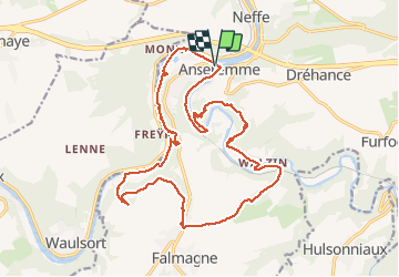

Length
20 km

Max alt
221 m

Uphill gradient
539 m
Km-Effort
28 km

Min alt
89 m

Downhill gradient
538 m
Boucle
Yes
Creation date :
2019-12-14 08:20:22.173
Updated on :
2019-12-16 08:15:55.788
7h14
Difficulty : Difficult

FREE GPS app for hiking
 SityTrail
IGN / Geographical institutes
SityTrail Plus
The world is yours!
About
Trail Walking of 20 km to be discovered at Wallonia, Namur, Dinant. This trail is proposed by Jaceu.
Positioning
Country:
Belgium
Region :
Wallonia
Department/Province :
Namur
Municipality :
Dinant
Location:
Anseremme
Start:(Dec)
Start:(UTM)
635981 ; 5566871 (31U) N.
Comments