


cutry

AlainQuent
User
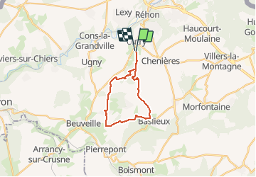

Length
17.5 km

Max alt
404 m

Uphill gradient
290 m
Km-Effort
21 km

Min alt
285 m

Downhill gradient
293 m
Boucle
Yes
Creation date :
2019-12-16 12:11:35.475
Updated on :
2019-12-16 16:45:52.312
4h31
Difficulty : Very easy

FREE GPS app for hiking
 SityTrail
IGN / Geographical institutes
SityTrail Plus
The world is yours!
About
Trail Walking of 17.5 km to be discovered at Grand Est, Meurthe-et-Moselle, Cutry. This trail is proposed by AlainQuent.
Description
marche Lysyane
Positioning
Country:
France
Region :
Grand Est
Department/Province :
Meurthe-et-Moselle
Municipality :
Cutry
Location:
Unknown
Start:(Dec)
Start:(UTM)
698633 ; 5484219 (31U) N.
Comments