


La Raye

ajd26
User
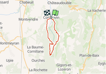

Length
19.1 km

Max alt
1006 m

Uphill gradient
767 m
Km-Effort
29 km

Min alt
359 m

Downhill gradient
768 m
Boucle
Yes
Creation date :
2019-12-19 08:06:24.0
Updated on :
2019-12-19 17:02:54.435
7h00
Difficulty : Medium

FREE GPS app for hiking
 SityTrail
IGN / Geographical institutes
SityTrail Plus
The world is yours!
About
Trail Walking of 19.1 km to be discovered at Auvergne-Rhône-Alpes, Drôme, Combovin. This trail is proposed by ajd26.
Description
Depuis Combovins, pas de Boissière, le pylône, pas de La Croix, pas du Buis
Positioning
Country:
France
Region :
Auvergne-Rhône-Alpes
Department/Province :
Drôme
Municipality :
Combovin
Location:
Unknown
Start:(Dec)
Start:(UTM)
664074 ; 4970796 (31T) N.
Comments