


baudinard corrige du22 decembre

clintest
User
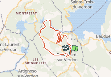

Length
16.3 km

Max alt
706 m

Uphill gradient
405 m
Km-Effort
22 km

Min alt
419 m

Downhill gradient
414 m
Boucle
Yes
Creation date :
2019-12-19 20:19:36.897
Updated on :
2019-12-19 20:21:03.191
--
Difficulty : Medium

FREE GPS app for hiking
 SityTrail
IGN / Geographical institutes
SityTrail Plus
The world is yours!
About
Trail On foot of 16.3 km to be discovered at Provence-Alpes-Côte d'Azur, Var, Baudinard-sur-Verdon. This trail is proposed by clintest.
Positioning
Country:
France
Region :
Provence-Alpes-Côte d'Azur
Department/Province :
Var
Municipality :
Baudinard-sur-Verdon
Location:
Unknown
Start:(Dec)
Start:(UTM)
269512 ; 4844504 (32T) N.
Comments