


chemery 2019

mimilolo
User
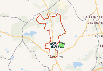

Length
14.8 km

Max alt
139 m

Uphill gradient
112 m
Km-Effort
16.3 km

Min alt
86 m

Downhill gradient
112 m
Boucle
Yes
Creation date :
2019-12-22 07:12:37.037
Updated on :
2019-12-22 10:13:25.584
2h59
Difficulty : Very easy

FREE GPS app for hiking
 SityTrail
IGN / Geographical institutes
SityTrail Plus
The world is yours!
About
Trail Walking of 14.8 km to be discovered at Centre-Loire Valley, Loir-et-Cher, Chémery. This trail is proposed by mimilolo.
Description
départ parking stade
circuit pmpiers
Photos


Positioning
Country:
France
Region :
Centre-Loire Valley
Department/Province :
Loir-et-Cher
Municipality :
Chémery
Location:
Unknown
Start:(Dec)
Start:(UTM)
385312 ; 5245179 (31T) N.
Comments