


23aa

jpmv
User
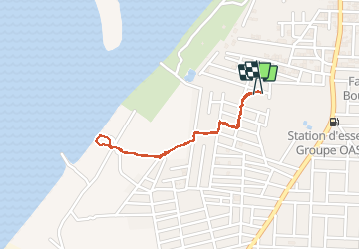

Length
2.1 km

Max alt
330 m

Uphill gradient
10 m
Km-Effort
2.2 km

Min alt
317 m

Downhill gradient
9 m
Boucle
Yes
Creation date :
2019-12-22 12:17:20.034
Updated on :
2019-12-22 13:17:40.504
50m
Difficulty : Very easy

FREE GPS app for hiking
 SityTrail
IGN / Geographical institutes
SityTrail Plus
The world is yours!
About
Trail Walking of 2.1 km to be discovered at Koulikoro, Kati Cercle. This trail is proposed by jpmv.
Positioning
Country:
Mali
Region :
Koulikoro
Department/Province :
Kati Cercle
Municipality :
Kabala
Location:
Unknown
Start:(Dec)
Start:(UTM)
604476 ; 1386782 (29P) N.
Comments