


Trial sur les hauts de Digne

mthomas30
User
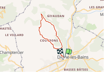

Length
12.6 km

Max alt
1422 m

Uphill gradient
892 m
Km-Effort
24 km

Min alt
652 m

Downhill gradient
883 m
Boucle
Yes
Creation date :
2019-12-26 14:30:42.298
Updated on :
2020-01-05 18:23:35.166
2h31
Difficulty : Medium

FREE GPS app for hiking
 SityTrail
IGN / Geographical institutes
SityTrail Plus
The world is yours!
About
Trail Trail of 12.6 km to be discovered at Provence-Alpes-Côte d'Azur, Alpes-de-Haute-Provence, Digne-les-Bains. This trail is proposed by mthomas30.
Positioning
Country:
France
Region :
Provence-Alpes-Côte d'Azur
Department/Province :
Alpes-de-Haute-Provence
Municipality :
Digne-les-Bains
Location:
Unknown
Start:(Dec)
Start:(UTM)
277886 ; 4885721 (32T) N.
Comments