


FLASSANS - St Bernard - les Angus - 11km

jpb83
User
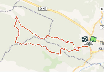

Length
10.8 km

Max alt
515 m

Uphill gradient
357 m
Km-Effort
15.6 km

Min alt
256 m

Downhill gradient
356 m
Boucle
Yes
Creation date :
2019-12-27 09:07:17.876
Updated on :
2019-12-27 09:14:14.269
1h15
Difficulty : Difficult

FREE GPS app for hiking
 SityTrail
IGN / Geographical institutes
SityTrail Plus
The world is yours!
About
Trail Running of 10.8 km to be discovered at Provence-Alpes-Côte d'Azur, Var, Flassans-sur-Issole. This trail is proposed by jpb83.
Positioning
Country:
France
Region :
Provence-Alpes-Côte d'Azur
Department/Province :
Var
Municipality :
Flassans-sur-Issole
Location:
Unknown
Start:(Dec)
Start:(UTM)
273318 ; 4805464 (32T) N.
Comments