


lader

maxEA65
User
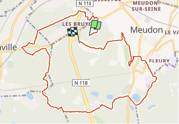

Length
13.4 km

Max alt
187 m

Uphill gradient
280 m
Km-Effort
17.1 km

Min alt
89 m

Downhill gradient
274 m
Boucle
No
Creation date :
2019-12-27 08:01:01.825
Updated on :
2019-12-27 11:30:36.455
3h28
Difficulty : Very easy

FREE GPS app for hiking
 SityTrail
IGN / Geographical institutes
SityTrail Plus
The world is yours!
About
Trail Walking of 13.4 km to be discovered at Ile-de-France, Hauts-de-Seine, Meudon. This trail is proposed by maxEA65.
Positioning
Country:
France
Region :
Ile-de-France
Department/Province :
Hauts-de-Seine
Municipality :
Meudon
Location:
Unknown
Start:(Dec)
Start:(UTM)
442650 ; 5406767 (31U) N.
Comments