


col de la vache

reneperrin
User
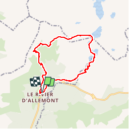

Length
15.3 km

Max alt
2575 m

Uphill gradient
1395 m
Km-Effort
34 km

Min alt
1225 m

Downhill gradient
1391 m
Boucle
Yes
Creation date :
2015-11-09 00:00:00.0
Updated on :
2015-11-09 00:00:00.0
6h39
Difficulty : Difficult

FREE GPS app for hiking
 SityTrail
IGN / Geographical institutes
SityTrail Plus
The world is yours!
About
Trail Walking of 15.3 km to be discovered at Auvergne-Rhône-Alpes, Isère, Allemond. This trail is proposed by reneperrin.


Positioning
Country:
France
Region :
Auvergne-Rhône-Alpes
Department/Province :
Isère
Municipality :
Allemond
Location:
Unknown
Start:(Dec)
Start:(UTM)
267713 ; 5009941 (32T) N.
Comments