Trail Walking Bretonnières - Romainmôtier - Fort - Photo
 vallorbe
vallorbe

User

© OpenStreetMap contributors
Length
Length
11.9 km
Max alt
Max alt
1158 m
Uphill gradient
Uphill gradient
560 m
Km-Effort
Km-Effort  
19.1 km
Min alt
Min alt
661 m
Downhill gradient
Downhill gradient
477 m
Boucle
Boucle
No
Creation date :
2014-12-11 00:00:00.0
Updated on :
2014-12-11 00:00:00.0

(0 Reviews)

Walking
Walking
3h40
Difficulty : Unknown

Scan this QR Code to open this trail in the SityTrail application

FREE GPS app for hiking

Logo SityTrail SityTrail

IGN / Geographical institutes

Download SityTrail from the App Store Download SityTrail from Google Play

Logo SityTrail SityTrail World

The world is yours!

Download SityTrail from the App Store Download SityTrail from Google Play Download SityTrail on Huawei AppGallery

About

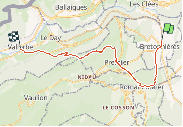
Trail Walking of 11.9 km to be discovered at Vaud, District du Jura-Nord vaudois, Bretonnières. This trail is proposed by vallorbe.

Description

Wanderung am besten an einem Wochenende zwischen Samstag, 3. Mai und Sonntag, 29. Juni oder von Samstag, 6. September bis Sonntag, 26. Oktober machen, weil die Festung dann geöffnet ist.
In der Hochsaison von Samstag, 5. Juli bis Sonntag, 24. August ist sie täglich geöffnet.

Vom Bahnhof Bretonnières dem Wanderweg nach Romainmôtier folgen. Beachten Sie in Bretonnières die kleine Kirche mit Zwiebelturm, eine Seltenheit in der Westschweiz, sowie einige Bauernhäuser aus dem 19. Jahrhundert.
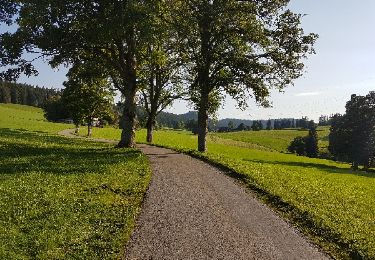
Wandern Sie dann durch den Forel-Wald, wo sich ein Abstecher in den Botanischen Garten anbietet.
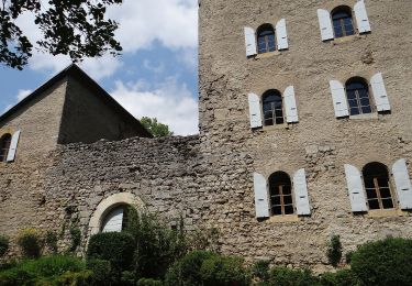
Am Waldausgang erblicken Sie Romainmôtier: Lassen Sie sich von der Abteikirche, dem Priorenhaus, der Klosterausstellung und der allgemeinen in diesem Dorf herrschenden Stimmung beeindrucken.
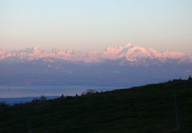
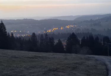
In Premier öffnet sich ein breites Panorama mit dem Neuenburgersee, dem Waadtländer Mittelland, den Berner, Waadtländer und Savoyer Alpen. Nach dem Aufstieg sind Sie vielleicht hungrig, weshalb ein Halt in der Alphütte Les Auges willkommen ist. Hier können Sie entweder ein Picknick machen oder aber eine der berühmten Käseschnitten geniessen.
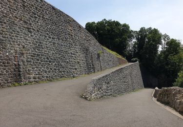
Nach einem Stück durch den Wald gelangen Sie auf den Kamm. Von dort erreichen Sie nach einem schnellen Abstieg die Festung Pré-Giroud; Sie haben Aussicht auf das Tal von Vallorbe, den Mont d''Or, Ballaigues und den Suchet, dessen Garnison von 1939 und 1945 zur Verteidigung bereit war.  
Von der Festung gibt es einen angenehmen Rückweg über die Strasse und dann links einen Waldweg, der oberhalb von Vallorbe endet. Über die Rue de l''Agriculture und die Rue de l''Orbe gelangen Sie nach Vallorbe, den einzigen Strassen, die vom Brand verschont blieben, der am 7. April 1883 das Dorfzentrum verwüstete.

Elevation profile

Points of interest

Point of interest Vallorbe - Poste - Photo
vallorbe
VALLORBE 
Point of interest Vallorbe - Fort de Pré Giroud - Photo
vallorbe
Point of interest Bretonnières - Gare de Bretonnières - Photo
vallorbe
BRETONNIÈRES 
Point of interest Romainmôtier-Envy - Abbatiale  - Photo
vallorbe
ROMAINMÔTIER-ENVY 

Positioning

Country:
Switzerland
Region :
Vaud
Department/Province :
District du Jura-Nord vaudois
Municipality :
Bretonnières
Location:
Unknown
Start:(UTM)
307016 ; 5176612 (32T) N.

Trails nearby

Trail On foot Les Clées - fixme - fixme - Photo
On foot
PRO

On foot

Easy
Les Clées, Vaud, District du Jura-Nord vaudois, Switzerland
4.1 km | 5.9 km-effort
1h 20min
No
Trail On foot Les Clées - Tourisme pédestre - Photo
On foot
PRO

On foot

Easy
Les Clées, Vaud, District du Jura-Nord vaudois, Switzerland
3.5 km | 4.5 km-effort
1h 0min
No
Trail On foot Ballaigues - Ballaigues-Vallorbe - Photo
On foot
PRO

On foot

Easy
Ballaigues, Vaud, District du Jura-Nord vaudois, Switzerland
5.1 km | 6.3 km-effort
1h 25min
No
Trail On foot Juriens - TP Mollendruz - Romainmôtie - Photo
On foot
PRO

On foot

Easy
Juriens, Vaud, District du Jura-Nord vaudois, Switzerland
7.8 km | 11.6 km-effort
2h 38min
No
Trail On foot Montcherand - Chemin nature pour tous - Photo
On foot
PRO

On foot

Easy
Montcherand, Vaud, District du Jura-Nord vaudois, Switzerland
3.8 km | 5.3 km-effort
1h 11min
No
Trail Walking Jougne - La poyette - Photo
Walking
mallovon

Walking

Medium
Jougne, Bourgogne-Franche-Comté, Doubs, France
11.8 km | 17.9 km-effort
4h 7min
Yes
Trail Cycle Lignerolle - Lignerolle - La Chaux de Fonds ( Jura Suisse) - Photo
Cycle
karawatsj

Cycle

Very difficult
Lignerolle, Vaud, District du Jura-Nord vaudois, Switzerland
81 km | 103 km-effort
8h 25min
No
Trail Other activity Romainmôtier-Envy - y10_Cascade du Dard - Photo
Other activity
GUIDE+

Other activity

Very easy
Romainmôtier-Envy, Vaud, District du Jura-Nord vaudois, Switzerland
7.4 km | 8.7 km-effort
2h 7min
No
Trail Other activity Romainmôtier-Envy - y10_brunnen_romainmoitier - Photo
Other activity
GUIDE+

Other activity

Very easy
Romainmôtier-Envy, Vaud, District du Jura-Nord vaudois, Switzerland
10.3 km | 13.1 km-effort
3h 17min
Yes


Close
My subscriptions