


roubion

aldaus
User
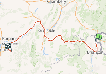

Length
229 km

Max alt
2062 m

Uphill gradient
3299 m
Km-Effort
277 km

Min alt
159 m

Downhill gradient
4464 m
Boucle
No
Creation date :
2019-12-29 09:02:16.611
Updated on :
2019-12-29 16:08:59.132
1h28
Difficulty : Very easy

FREE GPS app for hiking
 SityTrail
IGN / Geographical institutes
SityTrail Plus
The world is yours!
About
Trail Walking of 229 km to be discovered at Provence-Alpes-Côte d'Azur, Hautes-Alpes, Névache. This trail is proposed by aldaus.
Positioning
Country:
France
Region :
Provence-Alpes-Côte d'Azur
Department/Province :
Hautes-Alpes
Municipality :
Névache
Location:
Unknown
Start:(Dec)
Start:(UTM)
313798 ; 4987574 (32T) N.
Comments