


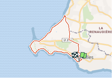
Circuit Pointe de Saint-Gildas

neitag61
User


1h46
Difficulty : Medium

FREE GPS app for hiking
 SityTrail
IGN / Geographical institutes
SityTrail Plus
The world is yours!
About
Trail Walking of 7.3 km to be discovered at Pays de la Loire, Loire-Atlantique, Préfailles. This trail is proposed by neitag61.
Description
Découvrez le littoral préfaillais en parcourant le tour de Saint-Gildas.
Départ Grande Plage ou Pointe St-Gildas.
Le sentier borde le littoral sur le sommet de la falaises côtières jusqu'à la Grande Plage.
On peut y découvrir de magnifiques chalets de bord de mer, datant pour certains de la fin du XIXe siècle, puis le plateau de la Chapelle, propriété commune et indivise des anciens Préfaillais.
Coupant ensuite au travers du bourg par de petites rues, l'itinéraire rejoint à nouveau le bord de mer à la Prée pour revenir vers le port.
Positioning
Comments