


Walkmeter-Walk-20180311-0759.gpx

ETMU5496
User

Length
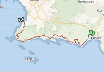
28 km

Max alt
428 m

Uphill gradient
1627 m
Km-Effort
50 km

Min alt
3 m

Downhill gradient
1588 m
Boucle
No
Creation date :
2019-12-29 19:02:04.357
Updated on :
2019-12-29 19:09:04.266
--
Difficulty : Difficult

FREE GPS app for hiking
 SityTrail
IGN / Geographical institutes
SityTrail Plus
The world is yours!
About
Trail On foot of 28 km to be discovered at Provence-Alpes-Côte d'Azur, Bouches-du-Rhône, Cassis. This trail is proposed by ETMU5496.
Description
Walkmeter Marche 11 mars 2018 à 07:59:26
Positioning
Country:
France
Region :
Provence-Alpes-Côte d'Azur
Department/Province :
Bouches-du-Rhône
Municipality :
Cassis
Location:
Unknown
Start:(Dec)
Start:(UTM)
704783 ; 4787416 (31T) N.
Comments