Trail On foot Brandivy - Circuit de l'étang, Brandivy - Photo

Circuit de l'étang, Brandivy

© OpenStreetMap contributors
Length
Length
10 km
Max alt
Max alt
157 m
Uphill gradient
Uphill gradient
192 m
Km-Effort
Km-Effort  
12.6 km
Min alt
Min alt
43 m
Downhill gradient
Downhill gradient
192 m
Boucle
Boucle
Yes
Creation date :
2019-12-30 08:19:46.743
Updated on :
2019-12-30 08:22:45.295

(0 Reviews)

On foot
On foot
--
Difficulty : Very easy

Scan this QR Code to open this trail in the SityTrail application

FREE GPS app for hiking

Logo SityTrail SityTrail

IGN / Geographical institutes

Download SityTrail from the App Store Download SityTrail from Google Play

Logo SityTrail SityTrail World

The world is yours!

Download SityTrail from the App Store Download SityTrail from Google Play Download SityTrail on Huawei AppGallery

About

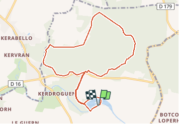
Trail On foot of 10 km to be discovered at Brittany, Morbihan, Brandivy. This trail is proposed by LaurentBernard.

Description

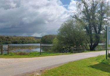
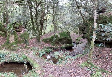
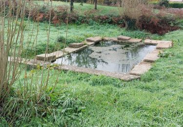
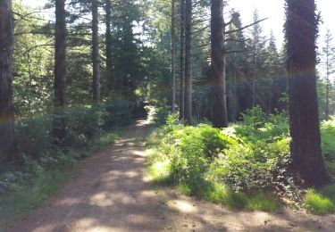
Situé sur les Landes de Lanvaux, ce circuit vous plonge dans la forêt domaniale de Lanvaux, gérée par l’Office National des Forêts. Les sentes sous les feuillus  alternent avec de larges allées bien entretenues. En début de parcours, l’étang de la forêt, créé artificiellement sur le Loc’h, est aménagé en base de loisirs.   Balisage : jaune (circuit PR)   ATTENTION, d'autres circuits ont été balisés dans la forêt. SE MUNIR DE CETTE CARTE pour ne pas se perdre en attendant le rebalisage. Merci de votre compréhension !

Elevation profile

Positioning

Country:
France
Region :
Brittany
Department/Province :
Morbihan
Municipality :
Brandivy
Location:
Unknown
Start:(UTM)
506397 ; 5293490 (30T) N.

Trails nearby

Trail Walking Brandivy - PR_56_Brandivy_AA_01_Circuit1b_Etang-De-La-Foret_20240417 - Photo
Walking
patrickdanilo

Walking

Easy
Brandivy, Brittany, Morbihan, France
9.8 km | 12.1 km-effort
2h 0min
Yes
Trail Walking Moustoir-Ac - PR_56_Moustoir-Ac_AA_01_Circuit1b_Au-Fil-De-L-Eau_20231014 - Photo
Walking
patrickdanilo

Walking

Easy
Moustoir-Ac, Brittany, Morbihan, France
8.8 km | 10.6 km-effort
1h 51min
Yes
Trail Walking Grand-Champ - PR_56_Grand-Champ_AA_01_Circuit1b_Tro-Gregam-10km_20221126 - Photo
Walking
patrickdanilo

Walking

Easy
Grand-Champ, Brittany, Morbihan, France
10.6 km | 12.3 km-effort
2h 18min
Yes
Trail Electric bike Pluvigner - Boucle dans la forêt de Florange à partir de Bieuzy Lanvaux - Photo
Electric bike
EricVIBERT

Electric bike

Medium
(1)
Pluvigner, Brittany, Morbihan, France
18.3 km | 23 km-effort
1h 38min
Yes
Trail Walking Brandivy - Forêt de Floranges - Photo
Walking
shadow

Walking

Very easy
(1)
Brandivy, Brittany, Morbihan, France
6 km | 7.4 km-effort
1h 37min
Yes
Trail Walking Grand-Champ - zer - Photo
Walking
bourdet

Walking

Very difficult
Grand-Champ, Brittany, Morbihan, France
197 km | 213 km-effort
0h 0min
No
Trail Nordic walking Grand-Champ - Ste Brigitte  - Photo
Nordic walking
yago1404

Nordic walking

Easy
Grand-Champ, Brittany, Morbihan, France
11.6 km | 13.7 km-effort
2h 56min
Yes
Trail Walking Grand-Champ - Coran Champ - Photo
Walking
leho.yannick@orange.fr

Walking

Medium
Grand-Champ, Brittany, Morbihan, France
9 km | 10.5 km-effort
2h 38min
No
Trail Walking Camors - CAMORS -alignements de Cornevec - Photo
Walking
shadow

Walking

Easy
Camors, Brittany, Morbihan, France
9.9 km | 11.9 km-effort
2h 34min
Yes


Close
My subscriptions