


paris sud

les randos d'Olivier
partout a pied et en moto

Length
21 km

Max alt
82 m

Uphill gradient
280 m
Km-Effort
25 km

Min alt
19 m

Downhill gradient
280 m
Boucle
Yes
Creation date :
2019-12-30 15:52:45.166
Updated on :
2020-01-06 09:33:51.484
5h00
Difficulty : Very easy

FREE GPS app for hiking
 SityTrail
IGN / Geographical institutes
SityTrail Plus
The world is yours!
About
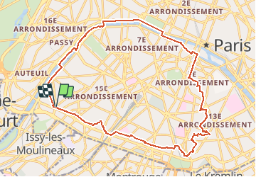
Trail On foot of 21 km to be discovered at Ile-de-France, Paris, Paris. This trail is proposed by les randos d'Olivier.
Positioning
Country:
France
Region :
Ile-de-France
Department/Province :
Paris
Municipality :
Paris
Location:
15th Arrondissement
Start:(Dec)
Start:(UTM)
447071 ; 5409583 (31U) N.
Comments