


Clo

surceneux
User
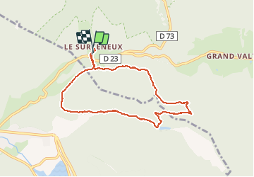

Length
7.3 km

Max alt
935 m

Uphill gradient
197 m
Km-Effort
9.9 km

Min alt
810 m

Downhill gradient
190 m
Boucle
Yes
Creation date :
2019-12-31 13:46:55.807
Updated on :
2019-12-31 16:04:29.985
1h30
Difficulty : Very easy

FREE GPS app for hiking
 SityTrail
IGN / Geographical institutes
SityTrail Plus
The world is yours!
About
Trail Walking of 7.3 km to be discovered at Grand Est, Vosges, Ban-sur-Meurthe-Clefcy. This trail is proposed by surceneux.
Description
cols port des planches-charbonniers-casuette-étang bb-surceneux
Positioning
Country:
France
Region :
Grand Est
Department/Province :
Vosges
Municipality :
Ban-sur-Meurthe-Clefcy
Location:
Unknown
Start:(Dec)
Start:(UTM)
347818 ; 5329031 (32U) N.
Comments