


2019-12-31 forêt Offendorf

Bernardb44
User
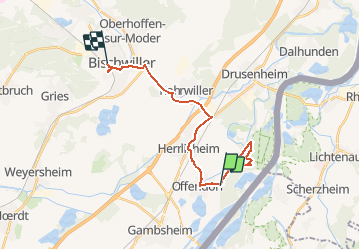

Length
19.8 km

Max alt
142 m

Uphill gradient
115 m
Km-Effort
21 km

Min alt
118 m

Downhill gradient
102 m
Boucle
No
Creation date :
2019-12-31 13:27:20.267
Updated on :
2019-12-31 16:13:13.314
2h45
Difficulty : Easy

FREE GPS app for hiking
 SityTrail
IGN / Geographical institutes
SityTrail Plus
The world is yours!
About
Trail Walking of 19.8 km to be discovered at Grand Est, Bas-Rhin, Offendorf. This trail is proposed by Bernardb44.
Positioning
Country:
France
Region :
Grand Est
Department/Province :
Bas-Rhin
Municipality :
Offendorf
Location:
Unknown
Start:(Dec)
Start:(UTM)
421142 ; 5396030 (32U) N.
Comments