


sugny frontière

staunn
User
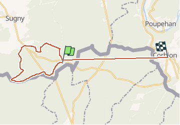

Length
13.9 km

Max alt
432 m

Uphill gradient
363 m
Km-Effort
18.9 km

Min alt
306 m

Downhill gradient
412 m
Boucle
No
Creation date :
2020-01-01 09:36:58.183
Updated on :
2020-01-01 11:47:08.301
1h55
Difficulty : Very easy

FREE GPS app for hiking
 SityTrail
IGN / Geographical institutes
SityTrail Plus
The world is yours!
About
Trail Walking of 13.9 km to be discovered at Wallonia, Namur, Vresse-sur-Semois. This trail is proposed by staunn.
Positioning
Country:
Belgium
Region :
Wallonia
Department/Province :
Namur
Municipality :
Vresse-sur-Semois
Location:
Sugny
Start:(Dec)
Start:(UTM)
639366 ; 5517557 (31U) N.
Comments