


Majjeville Aveyron

vidalou
User
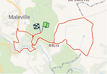

Length
7.1 km

Max alt
529 m

Uphill gradient
172 m
Km-Effort
9.5 km

Min alt
408 m

Downhill gradient
176 m
Boucle
Yes
Creation date :
2020-01-01 09:57:20.0
Updated on :
2020-01-01 12:14:06.594
2h14
Difficulty : Difficult

FREE GPS app for hiking
 SityTrail
IGN / Geographical institutes
SityTrail Plus
The world is yours!
About
Trail Walking of 7.1 km to be discovered at Occitania, Aveyron, Maleville. This trail is proposed by vidalou.
Description
Super sympa
Positioning
Country:
France
Region :
Occitania
Department/Province :
Aveyron
Municipality :
Maleville
Location:
Unknown
Start:(Dec)
Start:(UTM)
429010 ; 4916028 (31T) N.
Comments