


capdenac2020

bsddbs
User
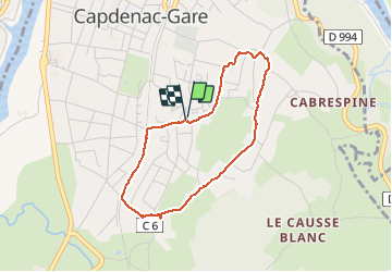

Length
3.4 km

Max alt
248 m

Uphill gradient
60 m
Km-Effort
4.2 km

Min alt
183 m

Downhill gradient
62 m
Boucle
Yes
Creation date :
2020-01-01 15:03:08.832
Updated on :
2020-01-01 16:17:22.781
1h13
Difficulty : Very easy

FREE GPS app for hiking
 SityTrail
IGN / Geographical institutes
SityTrail Plus
The world is yours!
About
Trail Walking of 3.4 km to be discovered at Occitania, Aveyron, Capdenac-Gare. This trail is proposed by bsddbs.
Positioning
Country:
France
Region :
Occitania
Department/Province :
Aveyron
Municipality :
Capdenac-Gare
Location:
Unknown
Start:(Dec)
Start:(UTM)
427283 ; 4935411 (31T) N.
Comments