


leboucherdaniel
User
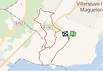

Length
11.9 km

Max alt
16 m

Uphill gradient
48 m
Km-Effort
12.6 km

Min alt
-4 m

Downhill gradient
48 m
Boucle
Yes
Creation date :
2020-01-01 20:10:31.376
Updated on :
2020-01-01 20:10:31.376

FREE GPS app for hiking
 SityTrail
IGN / Geographical institutes
SityTrail Plus
The world is yours!
About
Trail of 11.9 km to be discovered at Occitania, Hérault, Villeneuve-lès-Maguelone. This trail is proposed by leboucherdaniel.
Positioning
Country:
France
Region :
Occitania
Department/Province :
Hérault
Municipality :
Villeneuve-lès-Maguelone
Location:
Unknown
Start:(Dec)
Start:(UTM)
568578 ; 4818700 (31T) N.
Comments