


69 Montrottier vers Albigny

trietsch
User
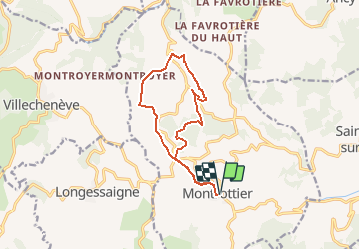

Length
12.5 km

Max alt
820 m

Uphill gradient
458 m
Km-Effort
18.6 km

Min alt
571 m

Downhill gradient
459 m
Boucle
Yes
Creation date :
2020-01-01 20:24:04.089
Updated on :
2020-01-01 20:26:20.627
3h52
Difficulty : Difficult

FREE GPS app for hiking
 SityTrail
IGN / Geographical institutes
SityTrail Plus
The world is yours!
About
Trail Walking of 12.5 km to be discovered at Auvergne-Rhône-Alpes, Rhône, Montrottier. This trail is proposed by trietsch.
Positioning
Country:
France
Region :
Auvergne-Rhône-Alpes
Department/Province :
Rhône
Municipality :
Montrottier
Location:
Unknown
Start:(Dec)
Start:(UTM)
614035 ; 5071822 (31T) N.
Comments