


caba

Sylvie Mathiot
User
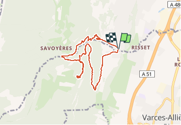

Length
8.7 km

Max alt
836 m

Uphill gradient
589 m
Km-Effort
16.6 km

Min alt
344 m

Downhill gradient
591 m
Boucle
Yes
Creation date :
2020-01-02 09:12:35.899
Updated on :
2020-01-02 15:10:12.594
5h02
Difficulty : Very easy

FREE GPS app for hiking
 SityTrail
IGN / Geographical institutes
SityTrail Plus
The world is yours!
About
Trail Walking of 8.7 km to be discovered at Auvergne-Rhône-Alpes, Isère, Claix. This trail is proposed by Sylvie Mathiot.
Description
cabane de Chabloz
Positioning
Country:
France
Region :
Auvergne-Rhône-Alpes
Department/Province :
Isère
Municipality :
Claix
Location:
Unknown
Start:(Dec)
Start:(UTM)
709674 ; 4998213 (31T) N.
Comments
Super cabane !