


montbel

lablaquiere
User
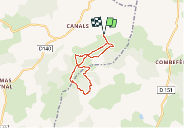

Length
6.1 km

Max alt
829 m

Uphill gradient
116 m
Km-Effort
7.7 km

Min alt
763 m

Downhill gradient
116 m
Boucle
Yes
Creation date :
2020-01-02 15:01:28.768
Updated on :
2020-01-02 16:29:48.203
1h28
Difficulty : Very easy

FREE GPS app for hiking
 SityTrail
IGN / Geographical institutes
SityTrail Plus
The world is yours!
About
Trail Walking of 6.1 km to be discovered at Occitania, Aveyron, Cornus. This trail is proposed by lablaquiere.
Positioning
Country:
France
Region :
Occitania
Department/Province :
Aveyron
Municipality :
Cornus
Location:
Unknown
Start:(Dec)
Start:(UTM)
520232 ; 4859067 (31T) N.
Comments