


2013-10-03 16h55m09_4 jeudi

jcm17
User

Length
24 km

Max alt
1051 m

Uphill gradient
2869 m
Km-Effort
61 km

Min alt
555 m

Downhill gradient
2675 m
Boucle
No
Creation date :
2014-12-10 00:00:00.0
Updated on :
2014-12-10 00:00:00.0
5h50
Difficulty : Medium

FREE GPS app for hiking
 SityTrail
IGN / Geographical institutes
SityTrail Plus
The world is yours!
About
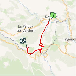
Trail Walking of 24 km to be discovered at Provence-Alpes-Côte d'Azur, Alpes-de-Haute-Provence, Rougon. This trail is proposed by jcm17.
Positioning
Country:
France
Region :
Provence-Alpes-Côte d'Azur
Department/Province :
Alpes-de-Haute-Provence
Municipality :
Rougon
Location:
Unknown
Start:(Dec)
Start:(UTM)
290573 ; 4851882 (32T) N.
Comments