Trail Walking Rougon - 2013-10-04 Trigance - Photo
 jcm17
jcm17

User

© OpenStreetMap contributors
Length
Length
21 km
Max alt
Max alt
1156 m
Uphill gradient
Uphill gradient
959 m
Km-Effort
Km-Effort  
34 km
Min alt
Min alt
624 m
Downhill gradient
Downhill gradient
959 m
Boucle
Boucle
Yes
Creation date :
2014-12-10 00:00:00.0
Updated on :
2014-12-10 00:00:00.0

(0 Reviews)

Walking
Walking
7h21
Difficulty : Difficult

Scan this QR Code to open this trail in the SityTrail application

FREE GPS app for hiking

Logo SityTrail SityTrail

IGN / Geographical institutes

Download SityTrail from the App Store Download SityTrail from Google Play

Logo SityTrail SityTrail World

The world is yours!

Download SityTrail from the App Store Download SityTrail from Google Play Download SityTrail on Huawei AppGallery

About

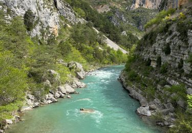
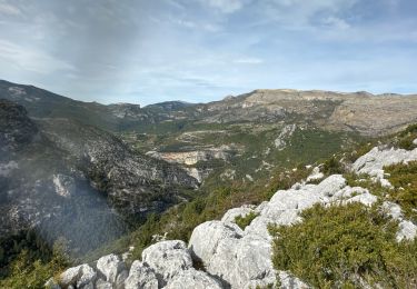
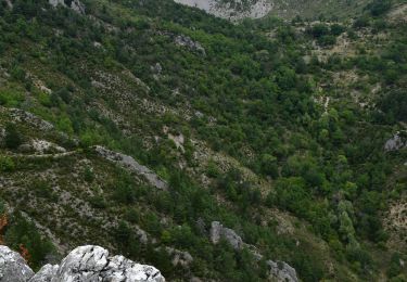
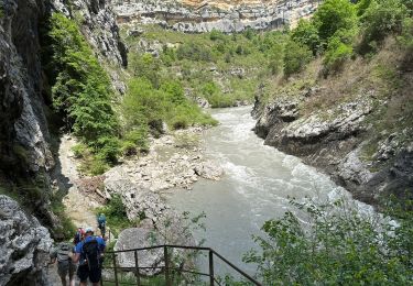
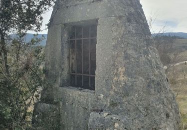
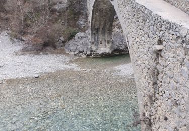
Trail Walking of 21 km to be discovered at Provence-Alpes-Côte d'Azur, Alpes-de-Haute-Provence, Rougon. This trail is proposed by jcm17.

Description

boucle au départ du pont de Carajuan : montée à la barre de l'Aigle, village de Rougon, Point Sublime, pont du Tusset, falaise de Rancoumas, col de Breis, hameau d'Entreverges, village de Trigance

Elevation profile

Positioning

Country:
France
Region :
Provence-Alpes-Côte d'Azur
Department/Province :
Alpes-de-Haute-Provence
Municipality :
Rougon
Location:
Unknown
Start:(UTM)
293386 ; 4851995 (32T) N.

Trails nearby

Trail Walking Rougon - Sentier Martel.Gorges du Verdon.06 05 16 - Photo
Walking
Dervalmarc

Walking

Medium
(3)
Rougon, Provence-Alpes-Côte d'Azur, Alpes-de-Haute-Provence, France
12.1 km | 26 km-effort
6h 20min
No
Trail Walking Rougon - Gorges du Verdon - de Point Sublime vers Encastel - AR - Photo
Walking
Orcal37

Walking

Medium
(2)
Rougon, Provence-Alpes-Côte d'Azur, Alpes-de-Haute-Provence, France
9.3 km | 18.6 km-effort
3h 15min
Yes
Trail Walking Trigance - Pont du Carajuan Rougon Pont du Tusset Belvédère de Rancoumas Trace réelle - Photo
Walking
jouans

Walking

Very difficult
Trigance, Provence-Alpes-Côte d'Azur, Var, France
21 km | 34 km-effort
7h 40min
Yes
Trail Walking Trigance - Trigance : Rancoumas-Carajuan - Photo
Walking
ETMU5496

Walking

Medium
Trigance, Provence-Alpes-Côte d'Azur, Var, France
16.4 km | 26 km-effort
5h 53min
No
Trail Walking Castellane - Clot d'Aremus - Chasteuil - Chapelle St Jean - Castellane - Photo
Walking
LtZIP

Walking

Easy
Castellane, Provence-Alpes-Côte d'Azur, Alpes-de-Haute-Provence, France
14.3 km | 19.8 km-effort
3h 54min
No
Trail Walking Rougon - Point sublime Verdon Blanc Martel 12 km - Photo
Walking
GUIDE
rvapeldo

Walking

Very difficult
Rougon, Provence-Alpes-Côte d'Azur, Alpes-de-Haute-Provence, France
12.3 km | 24 km-effort
5h 32min
Yes
Trail Walking Castellane - Castelane - Photo
Walking
avdem

Walking

Very easy
Castellane, Provence-Alpes-Côte d'Azur, Alpes-de-Haute-Provence, France
11.9 km | 21 km-effort
6h 48min
No
Trail Walking Trigance - 2023-03-07 Belvédère des vautours - Photo
Walking
GUIDE
Kargil

Walking

Medium
Trigance, Provence-Alpes-Côte d'Azur, Var, France
11.6 km | 17.6 km-effort
6h 18min
Yes
Trail Walking Rougon - 2023-02-24 Pont de Tusset - Rancoumas - Entreverges  - Photo
Walking
GUIDE
Kargil

Walking

Medium
Rougon, Provence-Alpes-Côte d'Azur, Alpes-de-Haute-Provence, France
10.8 km | 19.8 km-effort
6h 48min
Yes


Close
My subscriptions