


Du Chateau à A16 puis vers la foret domaniale

denissculier
User
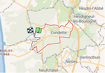

Length
13 km

Max alt
61 m

Uphill gradient
138 m
Km-Effort
14.8 km

Min alt
18 m

Downhill gradient
138 m
Boucle
Yes
Creation date :
2020-01-03 15:47:16.197
Updated on :
2020-01-03 16:08:09.982
3h12
Difficulty : Difficult

FREE GPS app for hiking
 SityTrail
IGN / Geographical institutes
SityTrail Plus
The world is yours!
About
Trail Nordic walking of 13 km to be discovered at Hauts-de-France, Pas-de-Calais, Condette. This trail is proposed by denissculier.
Positioning
Country:
France
Region :
Hauts-de-France
Department/Province :
Pas-de-Calais
Municipality :
Condette
Location:
Unknown
Start:(Dec)
Start:(UTM)
401987 ; 5611323 (31U) N.
Comments