


![Trail Walking Macornay - exp_02-01-20_[visibles] - Photo](https://media.geolcdn.com/t/1900/400/ext.pjpeg?maxdim=2&url=https%3A%2F%2Fstatic1.geolcdn.com%2Fsiteimages%2Fupload%2Ffiles%2F1553511878bg_sport_marche.png)
exp_02-01-20_[visibles]

drarep
User

Length
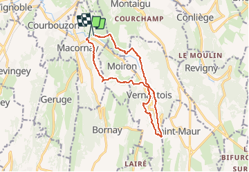
13.3 km

Max alt
574 m

Uphill gradient
459 m
Km-Effort
19.4 km

Min alt
274 m

Downhill gradient
461 m
Boucle
No
Creation date :
2020-01-03 17:41:28.053
Updated on :
2020-01-03 18:05:58.379
4h04
Difficulty : Medium

FREE GPS app for hiking
 SityTrail
IGN / Geographical institutes
SityTrail Plus
The world is yours!
About
Trail Walking of 13.3 km to be discovered at Bourgogne-Franche-Comté, Jura, Macornay. This trail is proposed by drarep.
Positioning
Country:
France
Region :
Bourgogne-Franche-Comté
Department/Province :
Jura
Municipality :
Macornay
Location:
Unknown
Start:(Dec)
Start:(UTM)
694837 ; 5169128 (31T) N.
Comments