


dropping 2020 versie 4 jan 2020.

deschepper
User
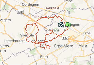

Length
29 km

Max alt
61 m

Uphill gradient
225 m
Km-Effort
32 km

Min alt
21 m

Downhill gradient
225 m
Boucle
Yes
Creation date :
2020-01-04 15:08:47.835
Updated on :
2020-01-04 15:08:47.835
--
Difficulty : Unknown

FREE GPS app for hiking
 SityTrail
IGN / Geographical institutes
SityTrail Plus
The world is yours!
About
Trail On foot of 29 km to be discovered at Flanders, East Flanders, Erpe-Mere. This trail is proposed by deschepper.

Positioning
Country:
Belgium
Region :
Flanders
Department/Province :
East Flanders
Municipality :
Erpe-Mere
Location:
Ottergem
Start:(Dec)
Start:(UTM)
566567 ; 5643090 (31U) N.
Comments