


69 St Martin en Haut. TR

trietsch
User
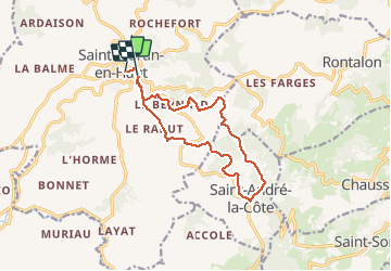

Length
13.3 km

Max alt
928 m

Uphill gradient
443 m
Km-Effort
19.1 km

Min alt
713 m

Downhill gradient
424 m
Boucle
No
Creation date :
2020-01-05 07:45:04.0
Updated on :
2020-01-05 11:27:07.533
3h41
Difficulty : Difficult

FREE GPS app for hiking
 SityTrail
IGN / Geographical institutes
SityTrail Plus
The world is yours!
About
Trail Walking of 13.3 km to be discovered at Auvergne-Rhône-Alpes, Rhône, Saint-Martin-en-Haut. This trail is proposed by trietsch.
Description
Belle balade pique possible et nombreux
Parc au départ et retour
Positioning
Country:
France
Region :
Auvergne-Rhône-Alpes
Department/Province :
Rhône
Municipality :
Saint-Martin-en-Haut
Location:
Unknown
Start:(Dec)
Start:(UTM)
621612 ; 5057278 (31T) N.
Comments