


Zemst

JanBekaert
User
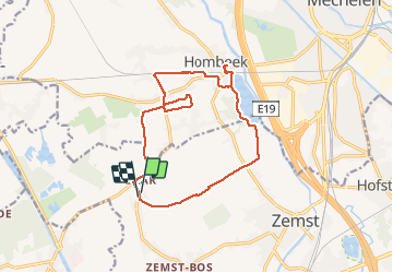

Length
14.7 km

Max alt
12 m

Uphill gradient
72 m
Km-Effort
15.7 km

Min alt
-4 m

Downhill gradient
72 m
Boucle
Yes
Creation date :
2020-01-05 07:09:49.965
Updated on :
2020-01-05 11:51:06.704
4h39
Difficulty : Very easy

FREE GPS app for hiking
 SityTrail
IGN / Geographical institutes
SityTrail Plus
The world is yours!
About
Trail Walking of 14.7 km to be discovered at Flanders, Flemish Brabant, Zemst. This trail is proposed by JanBekaert.
Positioning
Country:
Belgium
Region :
Flanders
Department/Province :
Flemish Brabant
Municipality :
Zemst
Location:
Zemst
Start:(Dec)
Start:(UTM)
599413 ; 5649651 (31U) N.
Comments