


La madone d’utelle

Arnaud Stévenard
User
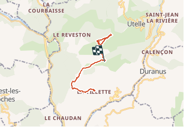

Length
9.7 km

Max alt
1188 m

Uphill gradient
751 m
Km-Effort
18.3 km

Min alt
612 m

Downhill gradient
330 m
Boucle
No
Creation date :
2020-01-05 08:04:16.0
Updated on :
2020-01-05 14:17:30.812
4h53
Difficulty : Medium

FREE GPS app for hiking
 SityTrail
IGN / Geographical institutes
SityTrail Plus
The world is yours!
About
Trail Walking of 9.7 km to be discovered at Provence-Alpes-Côte d'Azur, Maritime Alps, Utelle. This trail is proposed by Arnaud Stévenard.
Positioning
Country:
France
Region :
Provence-Alpes-Côte d'Azur
Department/Province :
Maritime Alps
Municipality :
Utelle
Location:
Unknown
Start:(Dec)
Start:(UTM)
357007 ; 4860519 (32T) N.
Comments