Trail Walking Laives - Laives - lacs et ville - Photo
© OpenStreetMap contributors
Length
Length
12.6 km
Max alt
Max alt
232 m
Uphill gradient
Uphill gradient
108 m
Km-Effort
Km-Effort  
14 km
Min alt
Min alt
175 m
Downhill gradient
Downhill gradient
108 m
Boucle
Boucle
Yes
Creation date :
2014-12-10 00:00:00.0
Updated on :
2014-12-10 00:00:00.0

(0 Reviews)

Walking
Walking
--
Difficulty : Easy

Scan this QR Code to open this trail in the SityTrail application

FREE GPS app for hiking

Logo SityTrail SityTrail

IGN / Geographical institutes

Download SityTrail from the App Store Download SityTrail from Google Play

Logo SityTrail SityTrail World

The world is yours!

Download SityTrail from the App Store Download SityTrail from Google Play Download SityTrail on Huawei AppGallery

About

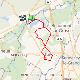
Trail Walking of 12.6 km to be discovered at Bourgogne-Franche-Comté, Saône-et-Loire, Laives. This trail is proposed by PapyChalon.

Description

Rando Club MGEN Chalon
Une promenade à faire en famille. Une bonne partie se fait sur chemin goudronnée.
Attention : pendant l'été, l'accès près des lacs (base de loisirs) en voiture est payant.

Elevation profile

Positioning

Country:
France
Region :
Bourgogne-Franche-Comté
Department/Province :
Saône-et-Loire
Municipality :
Laives
Location:
Unknown
Start:(UTM)
639303 ; 5169855 (31T) N.

Trails nearby

Trail Walking Laives - Laives  Montceau ragny page 106 - Photo
Walking
grasgilbert

Walking

Easy
(5)
Laives, Bourgogne-Franche-Comté, Saône-et-Loire, France
11.2 km | 15.1 km-effort
3h 1min
Yes
Trail Walking Sennecey-le-Grand - randonnée autour de Ruffey - Photo
Walking
charlolga

Walking

Easy
(1)
Sennecey-le-Grand, Bourgogne-Franche-Comté, Saône-et-Loire, France
12 km | 17.1 km-effort
3h 12min
Yes
Trail Nordic walking Laives - Laives - Photo
Nordic walking
hubert REVILLOT 2

Nordic walking

Very easy
Laives, Bourgogne-Franche-Comté, Saône-et-Loire, France
11.4 km | 15.8 km-effort
2h 10min
Yes
Trail On foot Sennecey-le-Grand - G . Sennecey le Grand - Le Chemin Ferré - La male campagne - Les Teppes - et retour par maison Dieu .  - Photo
On foot
jeanpaulcheyssac

On foot

Easy
(1)
Sennecey-le-Grand, Bourgogne-Franche-Comté, Saône-et-Loire, France
10.2 km | 11.1 km-effort
2h 30min
Yes
Trail Walking Saint-Ambreuil - G . St Ambreuil - Carré aux loups - Les mouilles - Sommière de la GD Toile - Sommière de la Gd Manche - Retour  par St Eloi .  - Photo
Walking
jeanpaulcheyssac

Walking

Medium
Saint-Ambreuil, Bourgogne-Franche-Comté, Saône-et-Loire, France
10.8 km | 11.6 km-effort
2h 37min
Yes
Trail Walking Lalheue - G . Lalheue - Laives - Vincelles et retour par Le Vernoy . - Photo
Walking
jeanpaulcheyssac

Walking

Difficult
Lalheue, Bourgogne-Franche-Comté, Saône-et-Loire, France
11.7 km | 12.5 km-effort
2h 50min
Yes
Trail Walking Laives - G . Lacs de Laives - Beaumont - Laives et retour . - Photo
Walking
jeanpaulcheyssac

Walking

Difficult
Laives, Bourgogne-Franche-Comté, Saône-et-Loire, France
11.2 km | 12.3 km-effort
2h 47min
Yes
Trail Mountain bike Sennecey-le-Grand - sennecey - la chapelle sous Brancion  - Photo
Mountain bike
XavierFaidix

Mountain bike

Medium
Sennecey-le-Grand, Bourgogne-Franche-Comté, Saône-et-Loire, France
36 km | 52 km-effort
3h 30min
Yes
Trail Walking Sennecey-le-Grand - jkkk - Photo
Walking
Hubert Revillot

Walking

Very difficult
Sennecey-le-Grand, Bourgogne-Franche-Comté, Saône-et-Loire, France
16.6 km | 21 km-effort
3h 37min
No


Close
My subscriptions