


Pignans, ND des Anges

francisdean
User
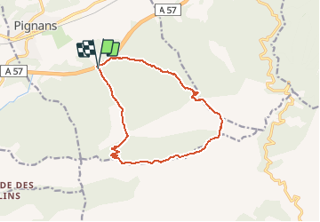

Length
14.5 km

Max alt
777 m

Uphill gradient
643 m
Km-Effort
23 km

Min alt
197 m

Downhill gradient
639 m
Boucle
Yes
Creation date :
2020-01-06 08:37:56.489
Updated on :
2020-01-08 11:48:55.29
4h21
Difficulty : Medium

FREE GPS app for hiking
 SityTrail
IGN / Geographical institutes
SityTrail Plus
The world is yours!
About
Trail Walking of 14.5 km to be discovered at Provence-Alpes-Côte d'Azur, Var, Pignans. This trail is proposed by francisdean.
Positioning
Country:
France
Region :
Provence-Alpes-Côte d'Azur
Department/Province :
Var
Municipality :
Pignans
Location:
Unknown
Start:(Dec)
Start:(UTM)
277213 ; 4796725 (32T) N.
Comments