


Antagnes

jipi2
User
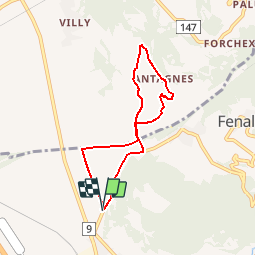

Length
6.2 km

Max alt
596 m

Uphill gradient
176 m
Km-Effort
8.5 km

Min alt
430 m

Downhill gradient
171 m
Boucle
Yes
Creation date :
2015-12-28 00:00:00.0
Updated on :
2015-12-28 00:00:00.0
1h53
Difficulty : Very easy

FREE GPS app for hiking
 SityTrail
IGN / Geographical institutes
SityTrail Plus
The world is yours!
About
Trail Walking of 6.2 km to be discovered at Vaud, District d'Aigle, Bex. This trail is proposed by jipi2.


Positioning
Country:
Switzerland
Region :
Vaud
Department/Province :
District d'Aigle
Municipality :
Bex
Location:
Unknown
Start:(Dec)
Start:(UTM)
346049 ; 5124990 (32T) N.
Comments