


La Forêt du Roi

raymondfn
User
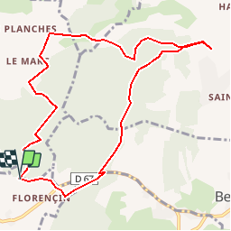

Length
10.3 km

Max alt
697 m

Uphill gradient
214 m
Km-Effort
13.1 km

Min alt
562 m

Downhill gradient
214 m
Boucle
Yes
Creation date :
2014-12-10 00:00:00.0
Updated on :
2014-12-10 00:00:00.0
3h15
Difficulty : Easy

FREE GPS app for hiking
 SityTrail
IGN / Geographical institutes
SityTrail Plus
The world is yours!
About
Trail Walking of 10.3 km to be discovered at Auvergne-Rhône-Alpes, Isère, Flachères. This trail is proposed by raymondfn.
Description
Flachères
Positioning
Country:
France
Region :
Auvergne-Rhône-Alpes
Department/Province :
Isère
Municipality :
Flachères
Location:
Unknown
Start:(Dec)
Start:(UTM)
681445 ; 5038422 (31T) N.
Comments