


antheor

tosan
User
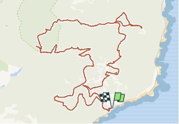

Length
19.3 km

Max alt
440 m

Uphill gradient
898 m
Km-Effort
31 km

Min alt
29 m

Downhill gradient
896 m
Boucle
Yes
Creation date :
2020-01-08 07:41:28.252
Updated on :
2020-01-10 18:27:17.769
7h31
Difficulty : Very easy

FREE GPS app for hiking
 SityTrail
IGN / Geographical institutes
SityTrail Plus
The world is yours!
About
Trail Walking of 19.3 km to be discovered at Provence-Alpes-Côte d'Azur, Var, Saint-Raphaël. This trail is proposed by tosan.
Positioning
Country:
France
Region :
Provence-Alpes-Côte d'Azur
Department/Province :
Var
Municipality :
Saint-Raphaël
Location:
Unknown
Start:(Dec)
Start:(UTM)
330446 ; 4812465 (32T) N.
Comments