


le marais salant de Lasné PM

LaurentBernard
User
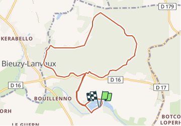

Length
10 km

Max alt
157 m

Uphill gradient
192 m
Km-Effort
12.6 km

Min alt
43 m

Downhill gradient
191 m
Boucle
Yes
Creation date :
2020-01-09 14:30:15.968
Updated on :
2022-06-08 12:18:28.101
--
Difficulty : Very easy

FREE GPS app for hiking
 SityTrail
IGN / Geographical institutes
SityTrail Plus
The world is yours!
About
Trail On foot of 10 km to be discovered at Brittany, Morbihan, Brandivy. This trail is proposed by LaurentBernard.
Positioning
Country:
France
Region :
Brittany
Department/Province :
Morbihan
Municipality :
Brandivy
Location:
Unknown
Start:(Dec)
Start:(UTM)
506397 ; 5293490 (30T) N.
Comments