


Ile aux Moines PM

LaurentBernard
User
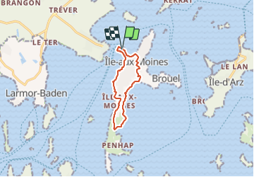

Length
8.8 km

Max alt
24 m

Uphill gradient
90 m
Km-Effort
10 km

Min alt
0 m

Downhill gradient
92 m
Boucle
Yes
Creation date :
2020-01-10 09:56:46.2
Updated on :
2022-04-13 11:33:31.436
--
Difficulty : Very easy

FREE GPS app for hiking
 SityTrail
IGN / Geographical institutes
SityTrail Plus
The world is yours!
About
Trail On foot of 8.8 km to be discovered at Brittany, Morbihan, Île-aux-Moines. This trail is proposed by LaurentBernard.
Positioning
Country:
France
Region :
Brittany
Department/Province :
Morbihan
Municipality :
Île-aux-Moines
Location:
Unknown
Start:(Dec)
Start:(UTM)
511085 ; 5271947 (30T) N.
Comments