


le cros

bouscaillou
User
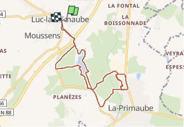

Length
10.1 km

Max alt
700 m

Uphill gradient
186 m
Km-Effort
12.6 km

Min alt
625 m

Downhill gradient
187 m
Boucle
No
Creation date :
2020-01-10 09:12:03.274
Updated on :
2020-01-10 11:18:53.246
2h05
Difficulty : Very easy

FREE GPS app for hiking
 SityTrail
IGN / Geographical institutes
SityTrail Plus
The world is yours!
About
Trail Nordic walking of 10.1 km to be discovered at Occitania, Aveyron, Luc-la-Primaube. This trail is proposed by bouscaillou.
Positioning
Country:
France
Region :
Occitania
Department/Province :
Aveyron
Municipality :
Luc-la-Primaube
Location:
Unknown
Start:(Dec)
Start:(UTM)
463048 ; 4906820 (31T) N.
Comments