


RS-Viriville-La Voie du Tram

raymondfn
User
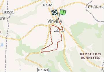

Length
5.6 km

Max alt
441 m

Uphill gradient
85 m
Km-Effort
6.7 km

Min alt
360 m

Downhill gradient
85 m
Boucle
Yes
Creation date :
2020-01-10 11:20:12.08
Updated on :
2020-01-10 16:51:32.999
43m
Difficulty : Easy

FREE GPS app for hiking
 SityTrail
IGN / Geographical institutes
SityTrail Plus
The world is yours!
About
Trail Walking of 5.6 km to be discovered at Auvergne-Rhône-Alpes, Isère, Viriville. This trail is proposed by raymondfn.
Positioning
Country:
France
Region :
Auvergne-Rhône-Alpes
Department/Province :
Isère
Municipality :
Viriville
Location:
Unknown
Start:(Dec)
Start:(UTM)
672905 ; 5020406 (31T) N.
Comments