


Rignac Blaireaux

bouscaillou
User
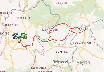

Length
21 km

Max alt
738 m

Uphill gradient
415 m
Km-Effort
26 km

Min alt
484 m

Downhill gradient
417 m
Boucle
Yes
Creation date :
2020-01-11 08:38:53.322
Updated on :
2020-01-11 14:19:28.314
5h37
Difficulty : Very easy

FREE GPS app for hiking
 SityTrail
IGN / Geographical institutes
SityTrail Plus
The world is yours!
About
Trail Walking of 21 km to be discovered at Occitania, Aveyron, Rignac. This trail is proposed by bouscaillou.
Positioning
Country:
France
Region :
Occitania
Department/Province :
Aveyron
Municipality :
Rignac
Location:
Unknown
Start:(Dec)
Start:(UTM)
443404 ; 4917097 (31T) N.
Comments