


Vieux Moulin 12 01 2020

Pachinou
User
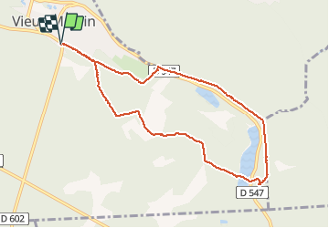

Length
8.4 km

Max alt
86 m

Uphill gradient
105 m
Km-Effort
9.8 km

Min alt
51 m

Downhill gradient
105 m
Boucle
Yes
Creation date :
2020-01-12 07:57:11.919
Updated on :
2020-01-12 11:29:11.594
3h14
Difficulty : Very easy

FREE GPS app for hiking
 SityTrail
IGN / Geographical institutes
SityTrail Plus
The world is yours!
About
Trail Walking of 8.4 km to be discovered at Hauts-de-France, Oise, Vieux-Moulin. This trail is proposed by Pachinou.
Positioning
Country:
France
Region :
Hauts-de-France
Department/Province :
Oise
Municipality :
Vieux-Moulin
Location:
Unknown
Start:(Dec)
Start:(UTM)
495019 ; 5470893 (31U) N.
Comments