


Champlon-forêt

damnot
User
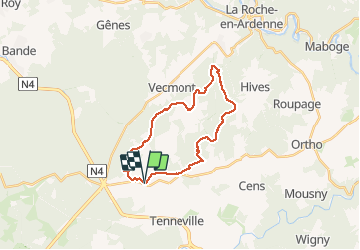

Length
23 km

Max alt
463 m

Uphill gradient
507 m
Km-Effort
29 km

Min alt
281 m

Downhill gradient
504 m
Boucle
Yes
Creation date :
2020-01-12 09:06:08.0
Updated on :
2020-01-12 14:40:01.229
5h06
Difficulty : Difficult

FREE GPS app for hiking
 SityTrail
IGN / Geographical institutes
SityTrail Plus
The world is yours!
About
Trail Walking of 23 km to be discovered at Wallonia, Luxembourg, Tenneville. This trail is proposed by damnot.
Description
Forêt
Photos


Positioning
Country:
Belgium
Region :
Wallonia
Department/Province :
Luxembourg
Municipality :
Tenneville
Location:
Champlon
Start:(Dec)
Start:(UTM)
678916 ; 5553613 (31U) N.
Comments