Trail On foot Neuviller-la-Roche - NatzwillChFeuPehreux - Photo
© OpenStreetMap contributors
Length
Length
16.9 km
Max alt
Max alt
1058 m
Uphill gradient
Uphill gradient
758 m
Km-Effort
Km-Effort  
27 km
Min alt
Min alt
564 m
Downhill gradient
Downhill gradient
766 m
Boucle
Boucle
Yes
Creation date :
2020-01-12 16:57:52.305
Updated on :
2023-01-07 10:26:40.845

(0 Reviews)

On foot
On foot
--
Difficulty : Difficult

Scan this QR Code to open this trail in the SityTrail application

FREE GPS app for hiking

Logo SityTrail SityTrail

IGN / Geographical institutes

Download SityTrail from the App Store Download SityTrail from Google Play

Logo SityTrail SityTrail Plus

The world is yours!

Download SityTrail from the App Store Download SityTrail from Google Play Download SityTrail on Huawei AppGallery

About

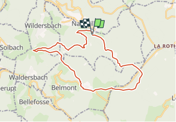
Trail On foot of 16.9 km to be discovered at Grand Est, Bas-Rhin, Neuviller-la-Roche. This trail is proposed by vaillantjm.

Description

Se garer sur le parking tout en haut de Natzwiller, au début de la route forestière.
Principalement en sous-bois, sauf la traversée du Champ du Feu et le col de la Pehreux. Seul le sentier des Roches au retour, peu avant Natzwiller, est un peu délicat.

Elevation profile

Positioning

Country:
France
Region :
Grand Est
Department/Province :
Bas-Rhin
Municipality :
Neuviller-la-Roche
Location:
Unknown
Start:(UTM)
371213 ; 5365938 (32U) N.


Close
My subscriptions