


Boucle de roquerlan par le pic de nore

Dupleix
User
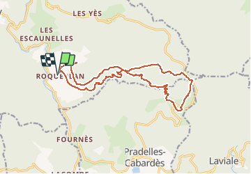

Length
18.2 km

Max alt
1214 m

Uphill gradient
586 m
Km-Effort
26 km

Min alt
707 m

Downhill gradient
587 m
Boucle
Yes
Creation date :
2020-01-13 10:12:05.098
Updated on :
2020-01-13 10:16:10.944
--
Difficulty : Difficult

FREE GPS app for hiking
 SityTrail
IGN / Geographical institutes
SityTrail Plus
The world is yours!
About
Trail On foot of 18.2 km to be discovered at Occitania, Tarn, Mazamet. This trail is proposed by Dupleix.
Description
Boucle de roquerlan 81200 mazamet.
A mazamet prendre la D54 direction passerelle,pic de nore, roquerlan,faire 12km et prendre a gauche roquerlan. Parking de randonneurs indiqué.
Positioning
Country:
France
Region :
Occitania
Department/Province :
Tarn
Municipality :
Mazamet
Location:
Unknown
Start:(Dec)
Start:(UTM)
451711 ; 4809532 (31T) N.
Comments