


2020-01-13_13h36m15_Evans Fraisans Rans 20 km 160m

gerardmicheline
User
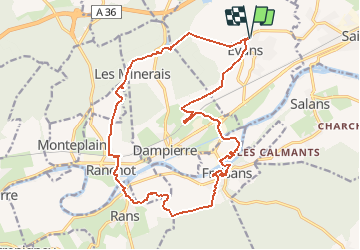

Length
20 km

Max alt
273 m

Uphill gradient
267 m
Km-Effort
24 km

Min alt
210 m

Downhill gradient
267 m
Boucle
Yes
Creation date :
2020-01-13 12:36:15.057
Updated on :
2020-01-13 12:36:17.65

FREE GPS app for hiking
 SityTrail
IGN / Geographical institutes
SityTrail Plus
The world is yours!
About
Trail of 20 km to be discovered at Bourgogne-Franche-Comté, Jura, Évans. This trail is proposed by gerardmicheline.
Positioning
Country:
France
Region :
Bourgogne-Franche-Comté
Department/Province :
Jura
Municipality :
Évans
Location:
Unknown
Start:(Dec)
Start:(UTM)
709869 ; 5228956 (31T) N.
Comments